Study Notes
GCSE Geography | Landforms of Deposition: Spits (Coastal Landscapes 9)
- Level:
- GCSE
- Board:
- AQA, Edexcel, OCR, Eduqas
Last updated 17 Oct 2024
Deposition has led to the formation of distinctive coastal features - we call these depositional landforms.
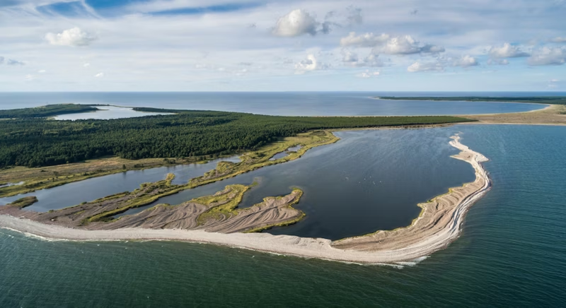
A spit is a long narrow beach made from sand or shingle that is joined to the mainland but stretches out into the sea. Spits form either at the mouth of an estuary or where the coastline suddenly changes direction.

How does a spit form?
Spits are formed by longshore drift carrying sediment along a coastline. The swash runs up the beach at an angle to the shore (from the same direction of the prevailing wind), however the backwash returns at right angles to the coastline due to gravity, meaning that material is carried along the coast in a zig-zag fashion. Spits form where there is a change in the shape of the coastline - the waves can't change direction here so they continue to carry and deposit sediment in the same direction as the original coastline, and as a result a spit starts to form.
A spit will continue to grow until the water becomes too deep (so there is less friction to slow the waves down and make them lose energy) or material is being removed faster than it is being deposited.
At the end of the spit the pebbles will become smaller and rounded because of the attrition taking place, they are also smaller because the longshore drift becomes weaker with distance from the original coastline so can only carry small material. The end of the spit will also have a recurved hooked end - this is because the dominant wind direction has changed, blowing material back towards the coastline slightly. There may also be old recurves further down the spit that mark the former end of the spit.
Behind the spit a salt marsh will develop in the sheltered shallow water - these are areas of high biodiversity, and are often classed as nature reserves or sites of special scientific interest (SSSIs)

How does a bar form?
Sometimes longshore drift causes a ridge of sand or shingle to grow across a bay, trapping water behind it as a lagoon. This is called a bar, or barrier beach. One of the most famous in the UK is Slapton Ley (pictured below). This is known as a bay bar and is visible at all times, unlike submerged bars and offshore barrier islands.
Submerged bars lie a little offshore, forming in shallow water where there is plenty of sediment on a beach, where the sediment has been transported off and then back onto the beach. The offshore bar is formed when destructive waves remove the sediment. You often see waves breaking some distance from the coast due to the friction caused by offshore bars. Submerged bars are so-named as they are only visible during low tide. At high tide, the bar is submerged and can only be identified by the waves breaking on it.

You might also like

Coasts: Dawlish Warren Flood Scheme
2nd January 2018
Resource Management: Energy - GCSE MCQ Quiz
Quizzes & Activities

Geography in the News: Can nature keep the waves at bay?
15th August 2022
Tri-Dominoes - Coastal Landscapes (Paper 1) | Revision Activity
Teaching Activities
